The 37-Mile LA Thru-Hike: Maps, Route, and What You’ll See
A walkable route across Los Angeles
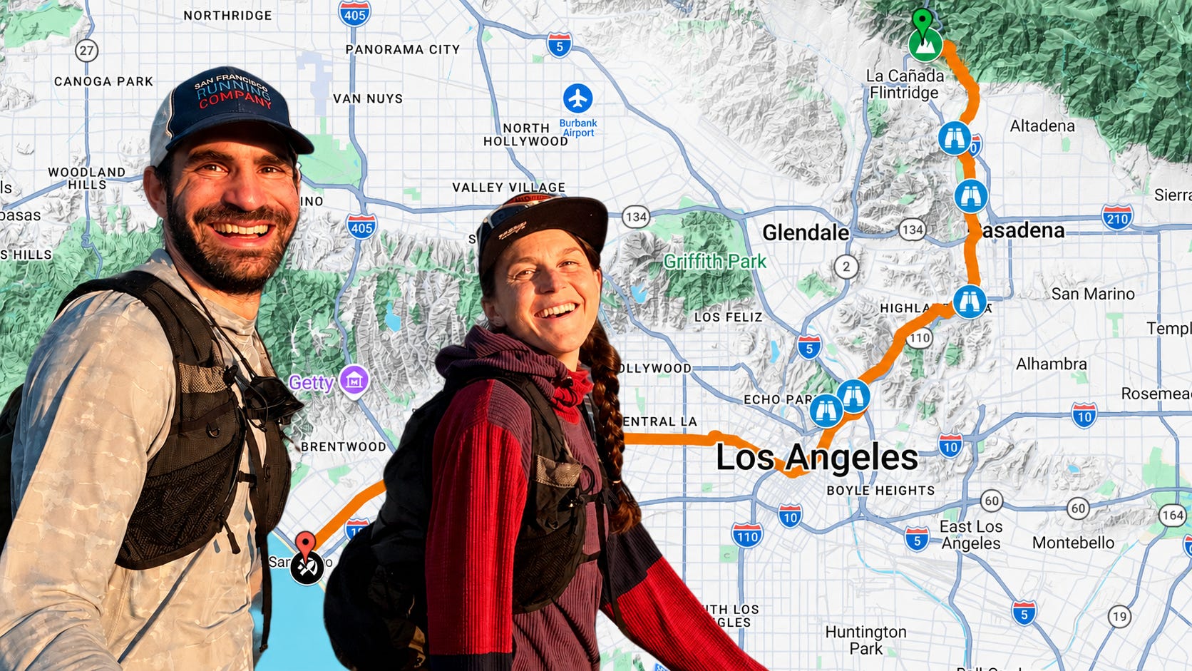
We walked across Los Angeles. It was 37 miles and took an entire day.
We pulled out a map and traced a route that would take us through as much of the city as possible. We started in the San Gabriel Mountains, descended to the Rose Bowl, crossed the LA River, wandered through Chinatown, downtown, and Koreatown, then curved through Beverly Hills before finishing at the Santa Monica Pier. In total, it was a loooong 37 miles, but the city was absolutely amazing!
By the end, we’re convinced that there is no better way to experience the city than to walk across it. You feel its scale in a way that’s impossible from inside a car.
This hike was so memorable that we wanted to share our route for others to enjoy! Since 37 miles is a pretty serious day hike, we broke it down into seven roughly 5-mile segments. Do one or a few at a time, or do them all at once, and you’ll complete one of the most unique urban thruhikes out there!
Segment 1: “A Taste of the Mountains”
The thruhike starts at an easy-to-miss pull-off on the Angeles Crest Highway (continue up this road and you’d hit the Pacific Crest Trail). Form there, you follow a small access road that quickly becomes a beautiful and surprisingly popular trail.
The route winds through the Angeles National Forest, 700,000 acres of public land immediately outside Los Angeles. We are always amazed by how quickly the LA area transforms from dense urban to remote mountain terrain.
The segment ends at the Dam that holds back Devil’s Gate Reservoir, the oldest flood-control facility in LA County. Keep your eyes peeled for the “Devil Rock”, which looks like a horned devil!


Segment 2: “River or Ditch?”
For most of this segment you’ll follow the banks of the Arroyo Seco on a hiking/biking path. At times, the creek feels impressively wild for being in the middle of Pasadena. In other stretches, though, it’s fully confined between concrete walls — a reminder that nearly every part of the city has been engineered in some way.
You’ll also walk right past the Rose Bowl, home of the famous college football bowl with the same name. Keep your eyes peeled to the east and you can spot Arroyo Seco Parkway to the east, widely considered the first freeway in the West and arguably the origin of LA’s car culture.


Segment 3: “Where Rivers Meet”
Segment 3 leaves the Arroyo Seco and heads into Los Angeles. You’ll pass through residential neighborhoods (where we spotted two coyotes!) before wandering into downtown Highland Park.
Highland Park is packed with unique restaurants, coffee-shops, and small stores, making it a great place to plan a “resupply” stop or grab a meal.
Eventually you’ll hit the confluence of the Arroyo Seco and the LA river. This is fitting point to to reflect on the city’s complicated relationship with water. More than half of LA’s water is imported, and the city has a long history of conflicts with communities hundreds of miles away over the diversion of local water resources through its aqueduct system.
You’ll walk right near Dodger Stadium, but to get a glimpse of it you’ll need to detour northwest and uphill from the mapped route. The segment ends in Chinatown, so don’t hesitate to grab some food or explore Chinatown’s markets.


Segment 4: “An Architects Delight”
If you’re looking for a true big-city experience, this is the segment to hike. Some of Los Angeles’s most fascinating architecture is on full display here, including the striking Walt Disney Concert Hall, as the route cuts directly through the heart of downtown.
One unexpected gem we discovered along the way was Grand Park, which features plants representing all six of the world’s floral kingdoms. It’s a surprisingly peaceful stretch in the middle of the city.


Segment 5: “The Best Food Outside of Seoul”
We LOVE Korean Food. As we made our way through Koreatown we found ourselves getting hungrier and hungrier. Fortunately, there is no shortage of restaurants to choose from.
We picked a spot serving bibimbap (Korean mixed rice) and decided to split a bowl to save space for later. But the restaurant surprised us with soup and unlimited appetizers, so we left with very full bellies.
Shortly after Koreatown comes one of the highlights of the entire thruhike: the La Brea Tar Pits. Oil still bubbles up to the surface here, and for thousands of years animals became trapped in tar and perished. Today, the site is an active archeological research area, completw with a museum, bubbling tar pits, and millions of fossils being studied. It’s definitely worth checking out!


Segment 6: “Movie Stars and Sports Cars”
Beverly Hills definitely feels fancy when you hike through it. Wearing hiking clothes with 25 miles of accumulated dirt and sweat, we felt a bit like the Clampetts from the old TV show The Beverly Hillbillies as meandered through.
Our trek had us in Beverly Hills on a Sunday evening, so most places were closed, but it seemed like every other storefront was either a luxury car dealership, a designer boutique, or a bank. This stretch of the thru-hike absolutely delivers the movie-star, old-Hollywood version of LA that most people picture in their heads.


Segment 7: “The End of the Road (Rt. 66)”
The final stretch of this thruhike takes you through Santa Monica and out to the Pacific Ocean.
When we were planning the route, we learned that the historic endpoint of Route 66 used to be here in Santa Monica, until the highway was decommissioned in 1985. But the end of the route is still marked on the Santa Monica Pier. If that’s a fitting ending for Route 66, it feels like an even better finish line for a thru-hike across LA!
As we approached the pier, a popular tourist destination, the sidewalk grew more and more crowded. Soon we were surrounded by people enjoying their evening in LA, just like we were, although probably without the 37-mile approach.
We snapped some photos, ate some churros, and then called an Uber for the 1-mile trip to our hotel. After 37 miles, we didn’t feel like doing a single step more!
Final Thoughts
This hike was incredible. Walking across Los Angeles gave us a completely different perspective on the city than you get from a car. We got to feel its scale, its variety, and how quickly it shifts from mountains to neighborhoods to ocean.
We left convinced that one of the best ways to understand LA is simply to walk it.
If you try one segment, a few, or the full route, let us know how it goes. We’d love to hear what you experience along the way.
Video
The Complete Route
If you’d rather do this hike in one big go, or design your own segments, here is our full route:


